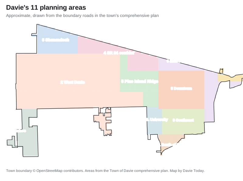
Davie's 11 planning areas, from Ivanhoe and Shenandoah to downtown and State Road 7, with ZIP codes, zoned high schools and Zillow home values for each.
Last checked Oct. 8, 2026. Sources: the Town of Davie’s comprehensive plan, Broward County Public Schools’ 2025-26 attendance boundaries, the Florida Department of Education’s 2026 school grades, the Zillow Home Value Index, the U.S. Census Bureau and OpenStreetMap.
Davie is a wide town: 22,910 acres, about 36 square miles, in the plan’s land-use count, from I-75 on the west to State Road 7 on the east, with Interstate 595 along most of its northern edge. The western half is horse country on one-acre lots; the eastern half holds the old downtown, the universities and most of the shops. The town’s comprehensive plan divides it into 11 planning areas, “based upon generally identifiable development patterns which are unique to the area.” This guide uses those areas, with the names the plan and the map give them.
Three things to know before you choose an address
- School zones do not follow town lines. Davie addresses are zoned for six different public high schools, some of them in Plantation, Cooper City, Pembroke Pines, Hollywood and Fort Lauderdale. Check every address in the district’s Find My School tool.
- ZIP codes cross town lines too. Most of Davie’s ZIP codes also cover parts of Plantation, Cooper City, Southwest Ranches or unincorporated Broward County, so ZIP home values are not Davie-only.
- Trash days depend on which side of Flamingo Road you live. See trash and recycling.
How Davie is laid out
- Highways: I-595 runs east to west along the north edge, with exits from Flamingo Road (Exit 2) to State Road 7 (Exit 9). I-75 runs north to south on the west side, with exits at Sheridan Street (11), Griffin Road (13) and I-595 (19). Florida’s Turnpike crosses the east side, with exits at Griffin Road (53) and I-595 (54). Exit numbers are from OpenStreetMap.
- Main roads: University Drive, Davie Road, Pine Island Road, Nob Hill Road and Flamingo Road run north to south. Griffin Road, Orange Drive, Stirling Road, Nova Drive and SW 14th Street run east to west.
- ZIP codes: the Census Bureau counts six ZIP codes with at least a tenth of their land in Davie: 33314, 33324, 33325, 33328, 33330 and 33331.
- Neighbors: Plantation and Sunrise to the north, Weston to the west, Southwest Ranches, Cooper City and Hollywood to the south, and Fort Lauderdale and unincorporated Broward to the east. See your town, county and neighbors.
Every area at a glance
Typical values are the Zillow Home Value Index for each area’s main ZIP code in August 2026. The index is a modeled typical value for the middle third of homes, not a sale price. High schools are from the district’s 2025-26 attendance boundaries.
| Area (plan number) | Main ZIP | Zoned high school | Typical value, main ZIP | Guide |
|---|---|---|---|---|
| Ivanhoe (1) | 33331 | West Broward | $848,482 | Ivanhoe |
| West Davie (2) | 33330 | Western; Cooper City in one pocket | $1,113,257 | West Davie |
| Shenandoah (3) | 33325 | Western | $608,346 | Shenandoah |
| State Road 84 corridor (4) | 33324 | Western; South Plantation | $352,275 | SR 84 corridor |
| Pine Island Ridge (5) | 33328 | Western | $626,047 | Pine Island Ridge |
| East Davie and State Road 7 (6) | 33314 | South Plantation; Stranahan; Hollywood Hills | $397,432 | East Davie |
| Former Hacienda Village (7) | 33312 | Stranahan | $483,310 | Below on this page |
| Downtown and university area (8) | 33314 | Hollywood Hills; Stranahan; South Plantation | $397,432 | Downtown |
| Southeast Davie (9) | 33314 | Hollywood Hills | $397,432 | Southeast Davie |
| South University Drive (10) | 33328 | Cooper City; Hollywood Hills | $626,047 | South University Drive |
| South of Stirling Road (11) | 33024 | Hollywood Hills | $473,138 | Below on this page |
The town-wide typical value was $516,933 in August 2026, down 2.1% in a year. More: Davie home prices and our Davie schools guide, which lists every school’s state grade.
The areas
Ivanhoe (Planning Area 1). All land south of Griffin Road and west of SW 148th Avenue, cut by I-75. The plan says the Ivanhoe development makes up most of it, at about three homes an acre. Read more.
West Davie (Planning Area 2). The largest area, from I-75 to Pine Island Road between Stirling Road and SW 14th Street, mostly one home an acre. Vista View Park and Robbins Preserve are here. Read more.
Shenandoah (Planning Area 3). The northwest corner between I-75, I-595, SW 14th Street and Flamingo Road, with Western High and Flamingo Elementary inside it. Read more.
State Road 84 corridor (Planning Area 4). Flamingo Road to University Drive along I-595, planned communities at about five homes an acre and the SR 84 shops. Read more.
Pine Island Ridge (Planning Area 5). Nob Hill Road to University Drive south of Nova Drive, around the preserved oak ridge and next to Tree Tops Park. Read more.
East Davie and State Road 7 (Planning Area 6). The research park north of Nova Drive and the strip between Florida’s Turnpike and State Road 7, which the town is working to redevelop. Read more.
Downtown and the university area (Planning Area 8). Davie Road and Orange Drive, the Western-theme downtown, the rodeo grounds and the South Florida Education Center. Read more.
Southeast Davie (Planning Area 9). Griffin Road to Stirling Road between SW 76th Avenue and the Turnpike, which the plan calls mostly agricultural. Read more.
South University Drive (Planning Area 10). The University Drive shopping strip between Griffin and Stirling roads. Read more.
The former Hacienda Village (Planning Area 7)
The plan calls this the smallest planning area. It “encompasses what was once Hacienda Village,” which the town annexed in the late 1980s. It lies north of State Road 84 and south of the North New River Canal, stretching about a mile east of State Road 7. Most of it is set aside for conservation, because it holds the Hacienda Flores and Pond Apple Slough wetland mitigation sites, owned by Broward County and the Florida Department of Transportation. Part of the canal frontage is used for marine industry, and an apartment development occupies the western 20 acres. The plan notes that its isolated spot on the town’s eastern edge makes public safety service harder to provide.
- ZIP code: mostly 33312, where Zillow’s typical value was $483,310 in August 2026, down 2.2% in a year. That ZIP code is mostly Fort Lauderdale and unincorporated Broward.
- Schools (2025-26 zones): Stephen Foster Elementary (A for 2026), New River Middle (B) and Stranahan High (A).
- Getting around: I-595 Exit 9 (U.S. 441/State Road 7) is at the west end. By road it is about 5 miles to Town Hall and about 4 miles to Fort Lauderdale-Hollywood International Airport, measured on OpenStreetMap’s road network with the OSRM route planner.
South of Stirling Road (Planning Area 11)
A small triangle bounded by Stirling Road on the north, Davie Road Extension on the southeast and University Drive on the west. The plan describes apartments on the south side of Stirling Road at 8 to 16 homes an acre, one single-family subdivision at five an acre, small shops along Davie Road Extension and University Drive, and the town’s water and wastewater treatment plants.
- ZIP code: 33024, where Zillow’s typical value was $473,138 in August 2026, down 1.7%. That ZIP code is mostly Pembroke Pines and Hollywood.
- Schools (2025-26 zones): Pasadena Lakes Elementary for most streets and Driftwood Elementary for the rest (both B for 2026), Driftwood Middle (C) and Hollywood Hills High (C).
- Getting around: Broward County Transit Routes 2, 9 and 12 stop here, according to BCT’s summer 2026 schedule data. By road it is about 2 miles to Town Hall and about 7.5 miles to the airport.
How we built this
- The areas are the 11 planning areas in the Town of Davie’s comprehensive plan (Future Land Use Element, data and analysis report), with the boundaries and descriptions the plan gives. Where the plan names a development, we use that name; we name no other subdivisions. OpenStreetMap confirmed the place names Shenandoah, Pine Island Ridge, Downtown Davie, Playland Village and Hacienda Village inside the town limits.
- The map is ours, drawn from the plan’s boundary roads inside the town boundary from OpenStreetMap. It is approximate; the plan’s own Figure 4 is the official version.
- School zones come from Broward County Public Schools’ 2025-26 attendance boundary data, published by Broward County’s GIS office, laid over each area. Grades are the Florida Department of Education’s 2026 school grades.
- ZIP codes are from the Census Bureau’s ZIP code boundaries; home values from Zillow; distances are road distances measured with the OSRM route planner on OpenStreetMap data; bus routes from Broward County Transit’s published schedule data.
Map and place data © OpenStreetMap contributors. Related: moving to Davie, getting around Davie, property taxes and Davie vs Cooper City vs Plantation vs Pembroke Pines.
Frequently asked questions
What are the neighborhoods in Davie, Florida?
The town’s comprehensive plan divides Davie into 11 planning areas. They include Ivanhoe in the southwest, the West Davie ranch area, Shenandoah, the State Road 84 corridor, Pine Island Ridge, downtown and the university area, southeast Davie, South University Drive, east Davie along State Road 7, the former Hacienda Village and a small area south of Stirling Road.
What ZIP codes are in Davie, FL?
The Census Bureau lists six ZIP codes with at least a tenth of their land in Davie: 33314, 33324, 33325, 33328, 33330 and 33331. Small parts of the town are in 33024, 33312, 33317 and 33326.
What high school is Davie zoned for?
It depends on the address. Broward County Public Schools zones different parts of Davie for six high schools: Western, West Broward, Cooper City, South Plantation, Stranahan and Hollywood Hills. Use the district’s Find My School tool to check a specific address.
Is Davie a town or a city?
A town. The Census Bureau lists it as Davie town, Florida, with 108,346 residents in its 2020-2024 American Community Survey estimates, and it is governed by a town council.
Have your say